
2014In this year, we considered about the prospect of the SOP in construction, so we tried our best to develop several technologies like motion planning, automatic clustering method, steel beam hauling system and etc. We hope that we could eliminate the danger engineers may encounter and modify the methods used in the construction. Is there anything more important than the safety in the construction? The answer is totally " No ".
|
|
Motion Planning and Coordina-tion for Mobile Construction Machinery |
Inadequate tools for evaluating construction machinery management have resulted in engineers relying heavily on experience to plan and replan site management during short time frames, with a lack of consideration for the movement of different construction machinery and the coordination of multiple construction machines. This study proposes a four-step motion planning and coordination method to evaluate construction machinery management.
|
由於用以評估工地機具管理工具的不合適,工程師往往須在極短的時間內倚賴經驗來擬定計畫,包含機具在工地中的往來以及多樣工具的協作等等。這項研究提出一個四步驟的協作計劃來簡易評估工地機具的管理。
|
Automatic clustering method for real-time construc-tion simulation |
In this paper, in order to reduce the computational cost of the real-time simulation, we develop an automatic clustering method, called the Propagation Clustering Method (PCM). PCM employs k-means clustering to iteratively cluster objects into multiple groups.
|
在這篇論文中,為了減少即時模擬的資料運算時間,我們研究出一個自動聚類方法(PMC),這項方法能自動以迭代方式聚集物件於多個群組。
|
|
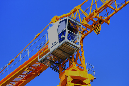
Control of fast crane operation
|
This research provided a simple vibration control method for fast crane operation using an open-loop control approach.
Our method is to reduce the sway angle and to reach high speed operation. The proposed method maintains a small sway angle in fast speed while the other open-loop methods do not. |
這項研究提供一個用於快速吊車系統的簡易振盪控制方法,並運用「開放式迴圈」的控制方式。我們的方法主要為減少擺角及達到最高運行速度,並與「開放式迴圈」的其他方法比較。
|
Development of a Steel Beam Hauling System |
We propose an autonomous joint system that will remove the need for laborers to work in elevated positions. The system consists of two subsystems: a steel beam hauling system and a bolting system. In this study, we focus on the design of the steel beam hauling system.
|
我們提出一項能去除工人在架高的位置工作需求的自主關節系統,這項系統包含兩項子系統 —— 鋼樑運輸系統及螺栓系統。在這項研究中,我們致力於設計鋼樑運輸系統。
|
|
A lightweight bridge inspection system
|
This research aims to develop an innovative bridge inspection system that is portable, simple, affordable, and can be easily applied on smaller yet large number bridges. We developed a systematic approach, which includes a lightweight inspection system using a dual-cable suspension mechanism, as well as strategies to conduct inspections.
|
這項研究目標發展一套創新的橋樑檢測系統,並擁有可攜性、簡待、可負擔性及易於安裝在多數小橋樑上等優點。我們研發出一套系統能運用雙電纜懸掛機構用做輕量級檢測,以及擬定策略進行檢測。
|
|
Optimized Integration of UAVs
|
This paper presents a strategy for digital terrain model (DTM), reconstruction using unmanned aerial vehicles (UAV), surveys, and image-based modeling technologies. The construction of a terrain model is considered critical since it can be used to study terrain transitions and conduct flooding simulations and field surveys.
|
這篇論文提出一項策略運用,包含數值地形模型、運用無人飛行載具進行重建、調查及影像基礎模型技術等領域。由於地形模型能運用於研究地勢變遷、洪水模擬及地形探勘等領域,這項技術被將被重點討論。
|
